With some 200 minor earthquakes occurring in Peru every year, it comes as no surprise that last week, the country’s most downloaded app addressed natural disaster warnings.
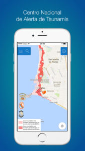
The Peruvian Navy teamed up with the National Tsunami Alert Center (CNAT) to develop an app called MGP Tsunami. The app provides a visualization of the National Seismic Report in which the most recent earthquakes occurring in the country and abroad are detailed. And as the world was watching the recent chaotic world weather reports last week, Peru was busy downloading, sending the app to the top of the charts of the most downloaded apps in Peru, even overtaking Facebook.
The app also provides information for users know what actions should be taken in case of tsunamis, as well as a map of evacuation routes and shelter locations if one were to hit land.
The app proved handy this year when Peru was confronted with El Niño, the phenomenon that triggered heavy rains causing floods in the coastal regions, and forced a state of emergency across the country.
MGP Tsunami was further tested when a 6.4 magnitude earthquake struck off the country’s south shore near the town of Camana on July 18 this year. More recently, the app proved its efficiency after the earthquake in Mexico this month, when Ecuador and Peru were added to the list of countries where a possible tsunami might hit following the quake. The alert, however, was soon canceled as MGP monitored the decrease in the waves’ height.
Natural disasters and smartphone apps

MGP Tsunamis app
With an 8.2-magnitude earthquake hitting Mexico on September 7, followed by Hurricane Irma plowing through the Caribbean and United States, it is no wonder that certain natural disaster apps are rocketing to the top of the most downloaded lists this month. Our smartphones are proving to be the number one tool to help and advise us under these circumstances.
In Mexico, within seconds of the earthquake striking, an app called SkyAlerts sent broadband signals to mobile devices across the country, triggering a message indicating the quake’s intensity. Part of the warning included a siren, ‘seismic alert’ which rang out repeatedly from the app.
As Hurricane Irma made its way towards the Caribbean, another app emerged — Zello Walkie Talkie — allowing immediate voice communication to others on a shared channel, providing additional early warnings about the storm.
With earthquakes and plate movements occurring off Latin America’s coastal stretch more frequently, these apps are proving essential for the region.


